
A groundbreaking new map has peeled back Antarctica’s colossal ice sheet, revealing the continent’s hidden bedrock landscape in stunning and unprecedented detail. This monumental achievement, born from a novel blend of satellite observation and advanced glaciological physics, promises to profoundly enhance our comprehension of the Earth’s southernmost continent and its critical role in global climate systems. Scientists involved in the research assert that this new topographical understanding is indispensable for predicting how Antarctica’s vast ice reserves will respond to ongoing climate change and its subsequent impact on global sea levels.
For centuries, much of what lay beneath Antarctica’s formidable icy shroud, which can be up to three miles (4.8km) thick in places, has remained one of Earth’s greatest geographical enigmas. Indeed, researchers often noted that more was known about the surface features of distant planets in our solar system than about the intricate "underbelly" of our own polar continent. Traditional methods for probing the subglacial landscape primarily relied on ice-penetrating radar, deployed from ground vehicles or aircraft. These surveys, while invaluable, typically generated data along widely spaced lines, leaving vast, uncharted territories between them. Imagine trying to map the intricate peaks and valleys of the Scottish Highlands or the European Alps with only occasional, widely separated aerial passes; the finer details, the crucial nuances of the topography, would be entirely missed.
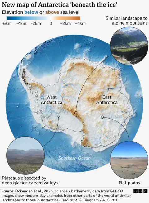
This new research, published in the esteemed academic journal Science, marks a significant departure from these conventional approaches. Led by Dr. Helen Ockenden, a climate researcher at the University of Grenoble-Alpes, and co-authored by Professor Robert Bingham, a glaciologist from the University of Edinburgh, the team developed a sophisticated methodology. They leveraged the rich trove of satellite data that provides highly accurate measurements of Antarctica’s surface elevation and, crucially, the velocity at which its glaciers flow. By applying the fundamental physics governing how ice deforms and moves over varying terrain, they could infer the underlying bedrock topography with remarkable precision.
Dr. Ockenden likened the advancement to upgrading from a "grainy pixel film camera" to a "properly zoomed-in digital image" of what truly lies beneath. The core principle of their method draws an analogy to kayaking on a river: just as eddies and ripples on the water’s surface can betray the presence of submerged rocks, the subtle variations in the ice sheet’s surface topography and velocity reveal the contours of the bedrock below. When a massive ice stream encounters a hidden ridge or dips into a subglacial valley, these interactions leave tell-tale signatures on the ice surface and influence its flow speed. By meticulously analyzing these surface expressions and applying complex glaciological models, the researchers could reconstruct the hidden landscape.
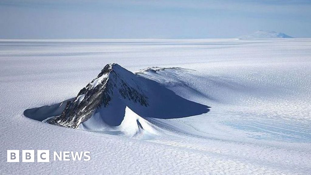
The results have been nothing short of revelatory. The new map has unmasked tens of thousands of previously undiscovered hills and ridges that were entirely missed by earlier, sparser surveys. Furthermore, it provides unprecedented clarity for known subglacial mountain ranges and deep canyons, resolving features with a level of detail previously unattainable. Professor Bingham expressed his excitement, stating, "I’m just so excited to look at that and just see the whole bed of Antarctica at once. I think that’s amazing."
Among the intriguing discoveries is a massive, deep channel incised into the bedrock of the Maud Subglacial Basin in East Antarctica. This remarkable geological feature averages 50 meters deep and 6 kilometers wide, stretching for nearly 400 kilometers – a distance comparable to traveling from London to Newcastle. Such a prominent channel could play a significant role in channeling meltwater or influencing ice flow dynamics in that region, potentially impacting the stability of the overlying ice. Dr. Ockenden emphasized the sheer wonder of these findings, comparing it to exploring the topography of Mars for the first time and encountering alien yet familiar landscapes.
The significance of this detailed subglacial map extends far beyond geographical curiosity. The precise contours of the bedrock are a primary control on the behavior of ice sheets and glaciers. The shape of the land beneath the ice dictates how quickly glaciers can flow, how they respond to warming ocean waters, and whether they are prone to rapid retreat. For instance, a downward-sloping bedrock can accelerate glacier retreat, making it more vulnerable to a phenomenon known as marine ice sheet instability (MISI), where a warming ocean can cause a runaway collapse of marine-terminating glaciers. Conversely, subglacial ridges can act as pinning points, temporarily stabilizing ice flow.
Therefore, a more accurate understanding of all the hidden ridges, hills, mountains, and channels is absolutely critical for improving the predictive capabilities of computer models that simulate Antarctica’s future behavior in a warming world. The future speed of melting in Antarctica is widely regarded as one of the biggest unknowns in climate science, directly influencing global sea-level rise projections. With the new map, scientists can feed more precise topographic data into these models, leading to more robust and reliable forecasts.
Dr. Peter Fretwell, a senior scientist at the British Antarctic Survey in Cambridge, who was not involved in the study but is a recognized expert in Antarctic mapping, lauded the new product as "really useful." He underscored its value in "fill[ing] in the gaps between those [traditional] surveys," creating a much more complete picture. This comprehensive view will be instrumental in refining our understanding of how Antarctica’s immense ice sheet contributes to global sea-level rise.
While this new map represents a monumental leap forward, the researchers acknowledge that it is not the final word. The methodology relies on sophisticated assumptions about ice flow physics, which, like any model, carry inherent uncertainties. Further research is needed to understand the composition of the rocks and sediments beneath the ice. Nevertheless, this study provides a powerful new baseline. Future ground, air, and space-based surveys will undoubtedly continue to refine these maps, validating the model’s predictions and uncovering even more intricate details.
Ultimately, this breakthrough provides glaciologists and climate scientists with an unprecedented tool to peer into Antarctica’s veiled past and predict its uncertain future. By illuminating the hidden landscape that shapes the continent’s immense ice sheet, this research lays a crucial foundation for more accurate climate predictions, helping humanity better prepare for the challenges of a warming planet and the inevitable changes to our coastlines.