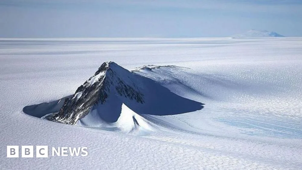
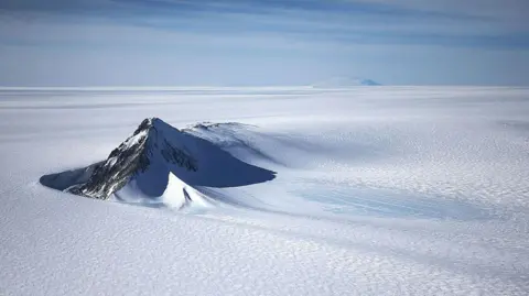
For centuries, the vast, enigmatic continent of Antarctica has guarded its secrets beneath an immense shroud of ice, some three miles (4.8km) thick in places. While satellites have provided an increasingly clear picture of its frozen surface, the complex topography lying beneath this colossal ice sheet has remained largely a mystery, with scientists often knowing more about the surface of distant planets than the landmass directly below the Earth’s southern pole. Now, a groundbreaking new map has peeled back this icy veil, revealing the landscape beneath Antarctica in unprecedented detail and promising to revolutionise our understanding of this critical region and its future.
The meticulously crafted map, published in the esteemed academic journal Science, is the culmination of innovative research by a team led by Dr. Helen Ockenden from the University of Grenoble-Alpes, with significant contributions from glaciologist Prof. Robert Bingham of the University of Edinburgh. Their work represents a monumental leap forward, moving from what Dr. Ockenden likens to a "grainy pixel film camera" to a "properly zoomed-in digital image of what’s really going on." This unparalleled resolution offers an entirely new perspective on the continent’s hidden "underbelly," exposing tens of thousands of previously undiscovered hills, ridges, valleys, and even vast subglacial channels.

Traditional methods for mapping Antarctica’s bedrock have relied primarily on airborne or ground-based radar surveys. These techniques involve emitting radio waves that penetrate the ice and bounce back from the underlying rock, providing depth measurements. However, the sheer scale of Antarctica means these surveys are often conducted along widely spaced tracks, sometimes tens of kilometres apart. As Prof. Bingham eloquently explains, "If you imagined the Scottish Highlands or the European Alps were covered by ice and the only way to understand their shape was the occasional flight several kilometres apart, there’s no way that you would see all these sharp mountains and valleys that we know to be there." This sparsity of data has forced scientists to interpolate vast areas, leaving significant gaps and uncertainties in their maps.
The new methodology bypasses these limitations by adopting a more holistic approach. Instead of solely relying on direct radar measurements, the researchers ingeniously combined high-resolution satellite data of the ice surface with sophisticated models of ice flow physics. The core principle behind this method is that the movement and deformation of the ice sheet at the surface are subtly influenced by the topography of the bedrock beneath. Just as a kayaker observes eddies and ripples on the water’s surface to infer the presence of rocks below, scientists can deduce the underlying landscape by analysing the ice’s surface elevation and velocity.
"It’s a little bit like if you’re kayaking in a river, and there’s rocks underneath the water, sometimes there’s eddies in the surface, which can tell you about the rocks under the water," Dr. Ockenden clarifies. "And ice obviously flows very differently to water, but still, when the ice is flowing over a ridge or a hill in the bedrock […] that manifests in the topography of the surface, but also in the velocity as well." By leveraging advanced satellite altimetry data, which precisely measures the ice surface height, and interferometric synthetic aperture radar (InSAR) data, which tracks ice movement with remarkable accuracy, the team was able to reverse-engineer the underlying bedrock topography. This technique allows them to "see" the subglacial landscape not just along isolated tracks, but across vast, continuous areas, dramatically improving the spatial resolution and completeness of the map.
The initial findings from this innovative mapping project are nothing short of astonishing. Beyond clarifying existing mountain ranges and canyons, the map has brought to light tens of thousands of previously unknown topographic features. These include intricate networks of hills and ridges that act as crucial controls on ice flow. One particularly striking discovery is a massive, deep channel located within the Maud Subglacial Basin in East Antarctica. This remarkable feature is, on average, 50 meters deep and 6 kilometres wide, stretching for an impressive 400 kilometres – a distance comparable to that between London and Newcastle. The existence of such a significant subglacial channel has profound implications for understanding how ice flows from the interior of the continent towards the coast, potentially acting as a conduit for faster ice discharge.
The implications of this unprecedented detail extend far beyond mere geographical curiosity. A comprehensive and accurate map of Antarctica’s subglacial topography is absolutely vital for improving the predictive power of ice sheet models. These complex computer models are essential tools for forecasting how Antarctica’s ice sheets will respond to ongoing climate change and, crucially, what that will mean for global sea-level rise. The bedrock geometry directly influences key processes such as basal friction, the formation of fast-flowing ice streams, and the stability of grounding lines – the points where the ice sheet lifts off the bedrock and begins to float on the ocean.
Subglacial hills and ridges, for instance, can act as pinning points, slowing down the retreat of glaciers and providing stability. Conversely, deep valleys and smooth plains can facilitate rapid ice flow and accelerate glacial retreat. In West Antarctica, much of the bedrock lies below sea level, making it particularly vulnerable to warm ocean currents melting the ice from below. A detailed understanding of the undulating landscape in these critical areas will allow scientists to more accurately simulate how marine-terminating glaciers might behave under various warming scenarios, predicting the rate at which they might thin and calve icebergs into the ocean.
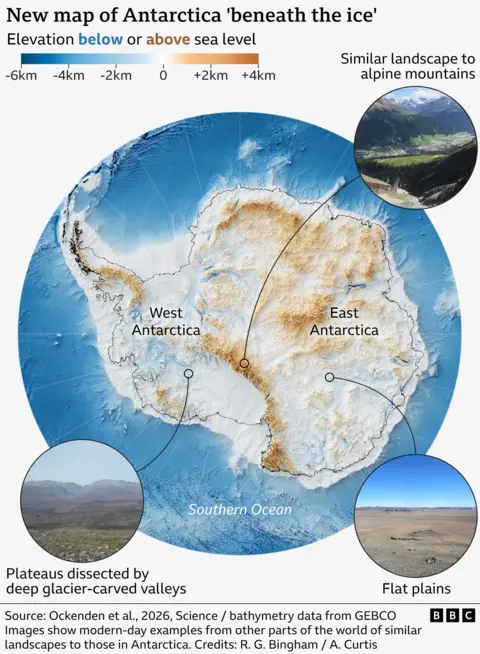
Prof. Bingham expressed his excitement, stating, "I’m just so excited to look at that and just see the whole bed of Antarctica at once. I think that’s amazing." Dr. Ockenden echoed this sentiment, drawing parallels to planetary exploration: "It’s like when you see a map of topography on Mars for the first time, and you’re like, ‘whoa, this is so interesting, this looks a bit like Scotland,’ or ‘this looks like nothing I’ve ever seen before’." The new map vividly portrays a diverse hidden world, with landscapes reminiscent of alpine mountains, plateaus dissected by deep glacier-carved valleys, and vast flat plains, all lying dormant beneath the ice.
While acknowledging that the map, like any model-based approach, is subject to uncertainties derived from assumptions about ice flow physics, the scientific community has largely welcomed this new development. Dr. Peter Fretwell, a senior scientist at the British Antarctic Survey in Cambridge, who was not directly involved in this study but has extensively contributed to previous mapping efforts, affirmed its value. "This is a really useful product," Fretwell commented, highlighting its ability to "fill in the gaps between those surveys" conducted using traditional radar methods. This collaborative approach, where new techniques complement existing data, is crucial for building the most complete picture possible.
The future speed of melting in Antarctica is widely considered one of the biggest unknowns in climate science, carrying profound implications for coastal communities worldwide. A more precise understanding of the subglacial landscape empowers researchers to build more robust and accurate models, thereby reducing uncertainties in sea-level rise projections. This will enable better planning and adaptation strategies for a changing world. As Dr. Fretwell concluded, "[This study gives] us a better picture of what’s going to happen in the future and how quickly ice in Antarctica will contribute to global sea-level rise." This new map is not merely a scientific achievement; it is a vital tool for understanding Earth’s future climate and our place within it.