 Nana Banana
El Niño and La Niña represent two of Earth’s most influential natural climate patterns, capable of profoundly altering temperatures, precipitation, and extreme weather events across the globe. These cyclical phenomena are integral to understanding global weather variability and have far-reaching implications for human societies and ecosystems. Currently, the world is experiencing La Niña conditions, as confirmed by the US science agency NOAA, with a transition to El Niño anticipated later in 2026, setting the stage for significant shifts in global weather patterns.
Understanding El Niño and La Niña: The El Niño Southern Oscillation (ENSO)

At their core, El Niño and La Niña are the opposing phases of a single, overarching natural climate phenomenon known as the El Niño Southern Oscillation (ENSO). This powerful oscillation originates in the tropical Pacific Ocean, specifically in the equatorial eastern and central regions, yet its atmospheric and oceanic teleconnections extend its influence far beyond its birthplace. The distinct characteristics of El Niño and La Niña are primarily defined by anomalies in sea surface temperatures (SSTs) and atmospheric pressure across this vast ocean basin.
During an El Niño event, the waters in the tropical eastern and central Pacific Ocean become anomalously warmer than average. Conversely, during a La Niña event, these same waters cool to below-average temperatures. These oceanic temperature shifts are intrinsically linked to corresponding changes in atmospheric pressure, forming a delicate dance between ocean and atmosphere. El Niño is typically characterized by atmospheric pressure that is above normal at Darwin, Australia (located in the western Pacific), and below normal at Tahiti, French Polynesia (situated in the central Pacific). La Niña presents the opposite scenario: below-normal pressure in Darwin and above-normal pressure in Tahiti. This seesaw in atmospheric pressure, known as the Southern Oscillation, drives the shifts in trade winds that are crucial to ENSO.
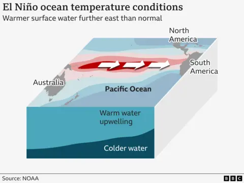
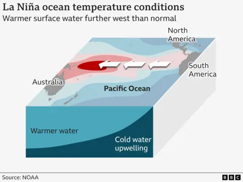
In "neutral" conditions – the periods between El Niño and La Niña – the Pacific Ocean exhibits a predictable temperature gradient. Surface waters are typically cooler in the eastern Pacific and progressively warmer towards the west. This normal state is maintained by strong east-to-west trade winds that blow consistently across the tropical Pacific. These winds push warm surface water towards the western Pacific, creating a vast pool of warm water near Indonesia and Australia. As this warm water accumulates in the west, colder, nutrient-rich water from the deep ocean rises to the surface in the eastern Pacific, a process called upwelling.

The onset of an El Niño disrupts this equilibrium. The trade winds, for reasons not fully understood but involving complex ocean-atmosphere feedback, weaken considerably or even reverse direction. This allows the accumulated warm surface waters in the western Pacific to surge eastward, spreading across the central and eastern equatorial Pacific. This eastward migration of warm water suppresses the normal upwelling of cold water along the coasts of South America, leading to warmer-than-average sea surface temperatures there. The phenomenon was first recognized by Peruvian fishermen in the 1600s, who noticed warm waters appearing off their coast around Christmas time, leading them to coin the term "El Niño de Navidad" – Spanish for "Christ Child."
In contrast, La Niña represents an intensification of the normal conditions. The east-to-west trade winds become unusually strong, pushing even more warm surface water further westward than usual. This enhances the warm pool in the western Pacific and leads to even more vigorous upwelling of cold, deep ocean water in the eastern Pacific. Consequently, sea surface temperatures in the central and eastern tropical Pacific become significantly cooler than average.
Global Impacts: How El Niño and La Niña Reshape Weather and Environment
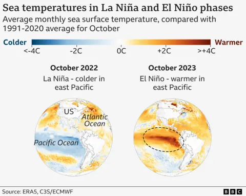
While each ENSO event possesses its unique nuances, scientists have identified consistent patterns of global weather and environmental impacts. The intensity and regional consequences can vary significantly depending on the strength of the El Niño or La Niña event and the time of year.
Perhaps the most direct and globally impactful consequence relates to temperature. Global average temperatures typically increase during El Niño years and decrease during La Niña years. This is because the widespread warming of the equatorial Pacific during El Niño releases a vast amount of heat into the atmosphere, contributing to warmer air temperatures worldwide. This effect can be so significant that strong El Niño events often coincide with record-breaking global heat years. Conversely, the extensive cooling of the Pacific during La Niña leads to a net reduction in heat released to the atmosphere, often moderating global temperatures, though they remain high in the context of long-term climate change.
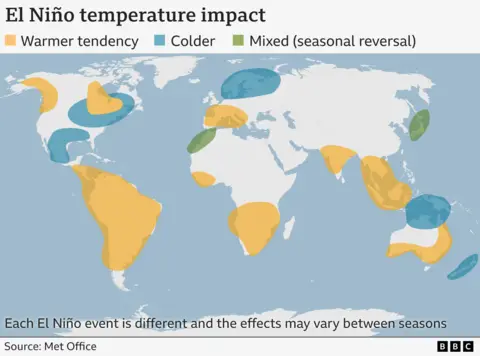
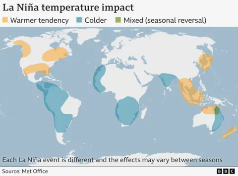
Regionally, temperature anomalies are more complex. During El Niño, warmer temperatures are commonly observed across much of South America, Southeast Asia, and southern Africa. However, some areas, like parts of Australia, might experience cooler periods due to altered rainfall patterns. La Niña, on the other hand, typically brings cooler temperatures to regions such as western South America and parts of western and southern Africa. The effects on mid-latitude regions, such as the UK, are more indirect and variable. The Met Office suggests that El Niño may increase the likelihood of a mild start but a cold end to the UK winter, while La Niña could make a colder start and mild end more probable.
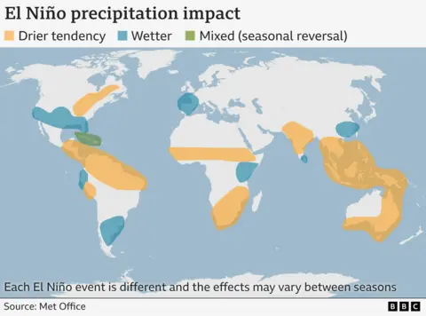
Precipitation patterns are also dramatically altered. During El Niño, the eastward shift of warm water influences the atmospheric jet streams. The Pacific jet stream’s strong air currents are pushed further south and east, bringing significantly wetter weather to the southern United States and the Gulf of Mexico. Conversely, tropical regions like Southeast Asia, Australia, and central Africa typically experience drier-than-average conditions. This can lead to severe droughts, increased risk of wildfires, and impacts on agriculture and water resources. La Niña generally reverses these trends, bringing wetter conditions to parts of Australia, Indonesia, and equatorial South America, while causing drier-than-normal conditions in the southern United States.
Tropical storm and hurricane activity also responds to ENSO. El Niño conditions tend to suppress tropical cyclone formation in the tropical Atlantic basin, including the south-eastern US, due to increased wind shear. Simultaneously, it often leads to more tropical storms in the central and eastern Pacific. During La Niña, the reverse is typically true: the Atlantic experiences an increased likelihood of hurricane activity, while the tropical Pacific sees fewer storms.
Beyond immediate weather, ENSO significantly impacts global carbon dioxide (CO2) levels. El Niño-induced droughts, particularly in tropical forests, can hinder plant growth and reduce their capacity to absorb CO2 from the atmosphere. Concurrently, the drier conditions often lead to an increase in wildfires, especially in regions like South Asia and the Amazon, which release vast amounts of stored carbon into the atmosphere. This combination often results in noticeable spikes in the rate of atmospheric CO2 increase during strong El Niño years.
Why El Niño and La Niña Matter: Socio-Economic and Ecological Implications
The extreme weather events exacerbated by El Niño and La Niña carry profound implications for infrastructure, food security, energy systems, and public health worldwide. Their influence extends beyond mere inconvenience, often triggering humanitarian crises and economic instability.
A striking example of ecological impact is seen in fishing communities along the west coast of South America. During El Niño events, the suppression of cold water upwelling means fewer essential nutrients rise from the ocean depths. This nutrient scarcity severely impacts the marine food web, reducing the availability of prey for commercially important species like squid and salmon, directly affecting the livelihoods of fishing communities. Conversely, La Niña often brings enhanced upwelling, leading to more productive fishing grounds.
Beyond fisheries, global agriculture is highly vulnerable. El Niño-induced droughts can devastate crop yields in major food-producing regions, leading to food shortages and price spikes for commodities like rice, wheat, coffee, and palm oil. Conversely, La Niña can bring excessive rainfall and flooding to other agricultural zones, similarly impacting harvests and supply chains. Water resources, critical for both human consumption and irrigation, are directly threatened by these shifts in precipitation, leading to water rationing and increased competition for dwindling supplies.
Public health also suffers. Altered temperature and precipitation patterns can expand the geographic range of disease vectors, leading to outbreaks of mosquito-borne illnesses like malaria, dengue, and Zika in new areas. Heatwaves intensified by El Niño can also lead to increased heat-related mortality and stress on healthcare systems. Economically, the costs associated with disaster relief, infrastructure repair, and reduced productivity can be astronomical, affecting national budgets and global markets.
Frequency and Future: How Often Do ENSO Episodes Occur, and Is Climate Change a Factor?
El Niño and La Niña episodes typically manifest every two to seven years. They generally last for about nine to twelve months, though some events can persist for longer periods, even stretching into multiple years. It’s important to note that these phases do not necessarily alternate; sometimes, there can be prolonged periods of neutral conditions or even back-to-back occurrences of the same phase. The current La Niña episode, for instance, began in mid-to-late 2024, marking a significant period of cool Pacific waters. Historically, strong El Niño events, such as those in 1997-98 and 2015-16, have left indelible marks on global weather records.
The question of whether anthropogenic climate change is influencing ENSO remains a complex and actively researched area in climate science. In 2021, the UN’s Intergovernmental Panel on Climate Change (IPCC) noted that ENSO episodes occurring since 1950 appear to be stronger than those observed between 1850 and 1950. However, the IPCC also highlighted that proxy data, such as tree rings, indicate that variations in the frequency and intensity of these events have occurred naturally since at least the 1400s. The panel concluded that there is "no clear evidence" that climate change has fundamentally altered the basic mechanism or overall frequency of ENSO events.
Despite this, the scientific community continues to explore the nuances. While the inherent oscillation is a natural phenomenon, a warming planet could potentially exacerbate the impacts of ENSO. For example, an El Niño event superimposed on already elevated global temperatures due to greenhouse gas emissions could lead to even more intense heatwaves and drier droughts than would occur in a pre-industrial climate. Similarly, La Niña’s typical cooling effect might be less pronounced, or its associated rainfall events more extreme, in a warmer world. Disentangling natural variability from human-induced changes within such a complex system remains a significant challenge, requiring ongoing research and sophisticated climate modeling to build a clearer consensus on the future of ENSO in a changing climate.
Additional reporting by the Visual Journalism team.


 Roy Suryo
 George Anjay
 Ramos Leo