
 Nana Banana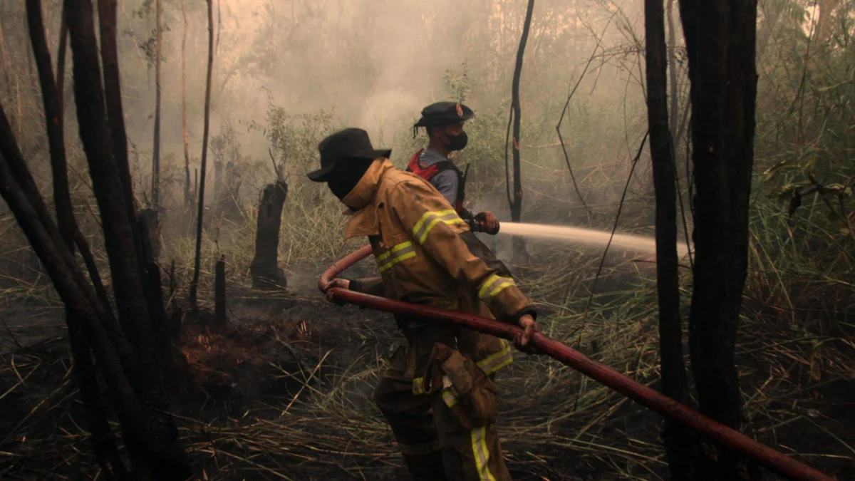
El Niño is a natural, recurring climate pattern, part of the larger El Niño-Southern Oscillation (ENSO) cycle, which typically manifests every two to seven years and persists for approximately a year. At its core, El Niño involves a dramatic alteration of oceanic and atmospheric conditions across the tropical Pacific. Under normal circumstances, strong easterly trade winds blow from east to west across the equatorial Pacific, pushing warm surface water towards Indonesia and Australia, and allowing cooler, nutrient-rich water to well up off the coast of South America. During an El Niño event, these trade winds weaken considerably, or can even reverse direction entirely. This weakening allows the vast pool of warm water, usually confined to the western Pacific, to spread eastward across the equatorial Pacific. As this warmer water expands, it releases immense amounts of heat into the atmosphere, which in turn influences atmospheric circulation patterns globally, boosting overall global temperatures and driving significant changes in weather systems across the planet. Forecasters meticulously track the development and strength of El Niño by observing sea surface temperatures in a specific region of the Pacific Ocean, known as the Niño 3.4 region. An El Niño is formally declared when these temperatures consistently register at least 0.5°C above their long-term average.
The measurement of El Niño’s strength, however, involves several indices. The recent record-breaking figures relate to daily measurements of sea surface temperature anomalies compared to the historical average, specifically using a metric similar to the Oceanic Niño Index (ONI). The ONI tracks the three-month running mean of sea surface temperature anomalies in the Niño 3.4 region. While the daily anomaly has shattered previous records, the multi-month average, which defines the official ONI strength, is still building towards its expected peak. This distinction highlights the rapid intensification observed in recent weeks. Nevertheless, the fact that a daily record has been set so early, weeks before the traditional peak season for El Niño (typically late autumn to early winter in the Northern Hemisphere), is a strong indicator of the event’s exceptional power.

Beyond the ONI, many scientists, including forecasters in the USA and Australia, also employ an alternative measure known as the Relative Oceanic Niño Index (RONI). The RONI offers a more nuanced perspective by measuring how warm the key El Niño region is relative to the rest of the tropical oceans. This approach is crucial in the context of ongoing global warming, as it helps differentiate between warming caused by the natural El Niño phenomenon and the background warming trend induced by climate change. By the RONI index, the current El Niño has not yet reached record-breaking status, primarily because the entire tropical ocean basin is warmer than historical averages. However, given the rapid intensification, it is highly probable that further announcements regarding new records, even by the RONI, will follow in the coming weeks and months. Professor Adam Scaife, Head of Long Range Prediction at the Met Office, emphasized the gravity of the situation, stating, "We have been signalling for months that the developing El Niño will be an unprecedented event. The fact that it has already exceeded previous records — with several weeks to go before it peaks later this year — shows the enormity of this El Niño." This statement underscores the scientific community’s growing concern and the recognition of this event’s exceptional nature.
While every El Niño event is unique, and its impacts on global weather patterns are never absolutely guaranteed to be proportional to its magnitude, the sheer strength of this developing phenomenon suggests widespread and significant effects. Professor Scaife noted, "Scientists are still assessing whether the impacts will be in proportion to its magnitude, but we are already seeing expected effects worldwide." El Niño typically increases the likelihood of severe storms and floods in certain regions, while simultaneously driving droughts and exacerbating wildfire risks in others. These atmospheric teleconnections result from the massive shift in heat distribution, altering global atmospheric circulation patterns, including the position and strength of jet streams.
For instance, El Niño years frequently correlate with below-average monsoon rainfall across India, a pattern that is already evident in this year’s data. Statistics from the India Meteorological Department reveal that, up to September 22nd, the crucial southwest monsoon season had delivered 15% less rain than normal. This deficit has profound implications for India’s vast agricultural sector, impacting critical crops like rice and pulses, and posing significant challenges to food security and the livelihoods of millions. Conversely, El Niño is known to influence tropical cyclone activity. A typical impact is a reduction in hurricane activity in the Atlantic basin, primarily due to increased wind shear in the upper atmosphere, which disrupts the formation and intensification of tropical storms. This year has seen a notable absence of Atlantic hurricanes for an extended period, setting a new record for the latest date without a hurricane forming since satellite monitoring of storms commenced.

Other anticipated and already-felt effects include an increased risk of devastating floods in coastal areas of Ecuador, Peru, and the southern United States. Warmer Pacific waters off the South American coast lead to enhanced evaporation and atmospheric instability, resulting in heavier precipitation and a higher incidence of flash floods, riverine flooding, and dangerous mudslides. These events can cause extensive damage to infrastructure, displace communities, and pose significant public health challenges. Simultaneously, El Niño intensifies the threat of prolonged drought conditions and widespread wildfires in regions like Brazil, Australia, and Indonesia. The image accompanying this report vividly illustrates the impact in Indonesia, where wildfires, exacerbated by El Niño’s dry conditions, are affecting an estimated 12.5 million people, according to the country’s health ministry. These fires contribute to severe air pollution, respiratory illnesses, and widespread ecological damage. The collective impact of these diverse weather phenomena—ranging from crop failures and water shortages to infrastructure destruction and public health crises—can have severe knock-on effects on global crop yields, exacerbate food insecurity, and destabilize economies around the world, particularly in developing nations heavily reliant on rain-fed agriculture.
While the United Kingdom is thousands of miles removed from the tropical Pacific, the far-reaching atmospheric teleconnections of El Niño can still exert an influence, though its effects tend to be less direct and more nuanced than in equatorial regions. Historically, strong El Niño events have been associated with an increased likelihood of wet and stormy conditions across north-west Europe during the late autumn and early winter months. The Met Office’s autumn forecast for this year explicitly highlighted "signals for increased rainfall and storminess" for the UK, particularly as November and December approach. A stark example of this association was the winter of 2015-2016, which coincided with a very strong El Niño. That period brought a relentless succession of major storms, including Storm Desmond, Storm Eva, and Frank, leading to what experts at the time described as the most extreme flooding on record, particularly across parts of Cumbria, Lancashire, and Yorkshire.
Beyond increased storminess, El Niño can also, in some instances, be linked to colder spells in the UK during the late winter. However, this connection is not as robust, and historical evidence presents a mixed picture, indicating the complex interplay of various atmospheric factors. For example, the severe "Big Freeze" of winter 2009-2010, which was, at the time, the coldest in three decades, did coincide with an El Niño event. Conversely, the winter of 2006-2007, also an El Niño year, was notably unseasonably warm, illustrating the variability and the lack of a simple, direct cause-and-effect relationship for UK winter temperatures. As this unprecedented El Niño event continues to develop and approaches its anticipated peak towards the end of the year, scientists will maintain rigorous monitoring of its evolution and its cascading impacts on weather patterns across the globe, all while considering the amplifying context of a warming planet. The scale of this El Niño demands continued vigilance and preparedness from governments and communities worldwide.


 Roy Suryo
 George Anjay
 Nakalama John
 Ramos Leo