
 Nana Banana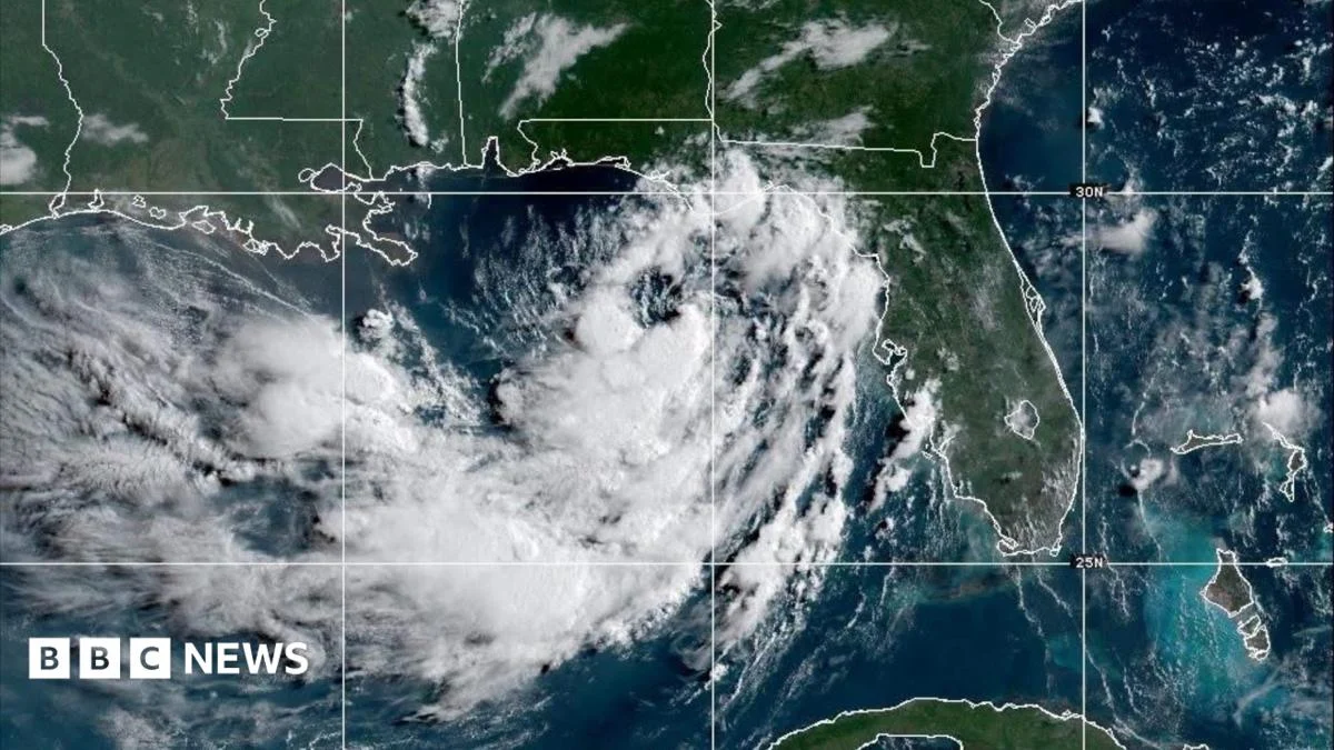
As of Monday, Tropical Storm Bertha was precisely located approximately 105 miles (165km) south of Panama City, Florida, exhibiting sustained windspeeds of 40mph (65 km/h). While these winds do not yet reach hurricane strength, they are well within the range capable of causing considerable disruption and damage, particularly along vulnerable coastlines. The Miami-based NHC meticulously tracks Bertha’s progression, stating, "Bertha will move near or along the northern Gulf coast during the next several days," indicating a prolonged period of impact for multiple states.
The storm’s anticipated trajectory suggests a westward drift towards Texas, bringing several states into its dangerous embrace. Alabama, Florida, Louisiana, and Mississippi are all projected to experience significant impacts, including extensive flooding and destructive storm surges. Forecasters paint a concerning picture, warning that some localized areas could be inundated with up to 8 inches (20cm) of rain by Friday. Such substantial rainfall in a short period carries a high potential for flash flooding, particularly in urban environments where impervious surfaces limit water absorption and in low-lying rural areas susceptible to rapid inundation. Beyond the immediate deluge, this could also lead to riverine flooding as smaller tributaries swell, potentially overwhelming drainage systems and causing prolonged water accumulation.
Adding another layer of threat, meteorologists have cautioned that "isolated" tornadoes could spawn within Florida as Bertha tracks nearby. Tropical systems are notorious for generating such localized, rapidly developing twisters, which can cause intense, concentrated damage with little to no warning, often making them exceptionally perilous. Residents are advised to have multiple ways to receive weather alerts and to be prepared to take shelter immediately should a tornado warning be issued for their area.
In an updated bulletin released Monday evening, forecasters indicated that the tropical storm might even build in strength over the next several days. This potential intensification raises concerns, particularly as the storm continues its slow, deliberate movement. The NHC’s models suggest a potential landfall in New Orleans, Louisiana, by Wednesday, a city famously vulnerable to tropical systems due to much of its infrastructure lying below sea level and its reliance on a complex levee system. A direct hit, even from a tropical storm, could severely test these defenses and infrastructure.
The bulletin further detailed that tropical storm-force winds, defined as sustained winds between 39 and 73 mph (63 to 118 km/h), extended an impressive 70 miles outward from the center of the storm. This wide reach means that areas far from the immediate core of Bertha could still experience damaging winds capable of downing tree branches, causing power outages, and turning loose outdoor items into dangerous projectiles. The storm’s slow forward motion of approximately 3 mph (5 km/h) to the north-west is also a critical factor; slower-moving storms tend to dump more rain over specific areas, exacerbating flood risks.
In response to the escalating threat, a tropical storm watch has been officially issued. This watch is in effect for a significant stretch of the Gulf Coast, extending from the Ochlockonee River in Florida westward to the Jefferson/Plaquemines Parish border in Louisiana. A "watch" signifies that tropical storm conditions are possible within the specified area, typically within 48 hours, urging residents to prepare for the onset of hazardous weather. It is a critical distinction from a "warning," which means such conditions are expected or are already occurring.
Officials have specifically highlighted that storm surges are expected to range between 1-4 feet along parts of the Louisiana and Mississippi coastlines. While not as catastrophic as the surges seen in major hurricanes, a 1-4 foot surge can still be life-threatening and highly destructive. It can inundate low-lying coastal roads, homes, and businesses, lead to significant coastal erosion, and contaminate freshwater supplies with saltwater. Flash flooding, as previously noted, remains a significant concern, particularly in densely populated urban areas where drainage systems can quickly become overwhelmed.
The arrival of Tropical Storm Bertha is particularly noteworthy as it coincides with sweltering summer heat already gripping the US South. This combination of extreme heat and high humidity, coupled with heavy rainfall, can create an exceptionally uncomfortable and potentially dangerous environment. Elevated temperatures can slow the drying process after floods, prolonging the impact and discomfort for affected residents, and increasing the risk of heat-related illnesses for those involved in recovery efforts.
Local authorities in New Orleans, acutely aware of the city’s historical susceptibility to flooding, have already initiated proactive measures. Sandbags are being distributed to residents to help stave off floodwaters from homes and businesses, a common and often effective first line of defense. Furthermore, residents have been explicitly asked to ensure that local storm drains are clear of debris. Clogged drains can significantly impede water runoff, turning otherwise manageable rainfall into substantial street flooding, underscoring the importance of community participation in preparedness.
Looking further ahead, Bertha is currently forecast to weaken back to a tropical depression by Thursday as it interacts with land and potentially encounters less favorable atmospheric conditions. The system may dissipate entirely by the end of the week as it nears the Texas coast, bringing a gradual cessation to the immediate threat. However, the residual moisture and potential for lingering heavy showers could still pose challenges even after its official dissipation.
This early-season activity underscores the potential for an active Atlantic hurricane season. Bertha marks only the second named storm of the season, following Tropical Storm Arthur, which brought some flooding to parts of the US last month. The early formation of two named storms suggests that residents along the Gulf and Atlantic coasts must remain vigilant and review their hurricane preparedness plans well in advance. The National Hurricane Center continues to advise all potentially affected areas to closely monitor official forecasts and heed the guidance of local emergency management officials as Tropical Storm Bertha continues its menacing approach.




 Roy Suryo

 Nakalama John
 atisusanti
 Ramos Leo